Click here for Online Trail Link (Trailforks)
Trails being update regularly.
Tips for Sharing Winter Trails
- Read the signs
- Don’t hike or snowshoe on groomed ski trails
- Don’t step on groomed tracks
- Share the trails
- Be prepared
We have a small but mighty and newly active group of volunteers working on all things at Mac Mills. The next big task for us is to post helpful trail signage and maps so you can plan your route. Watch for these updates coming soon. If you would like to get involved please email info@macmillstrails.ca
BEFORE YOU GO
- Drinking water: Not available
- Lift service: No
- Night riding: Absolutely!
- Pump track: Not yet
- Restrooms: Yes, and brand new facilities coming
- Fat bike grooming: yes
- E-bikes allowed: Yes
- Fee required: Yes, We ask for donations. Totally voluntary.
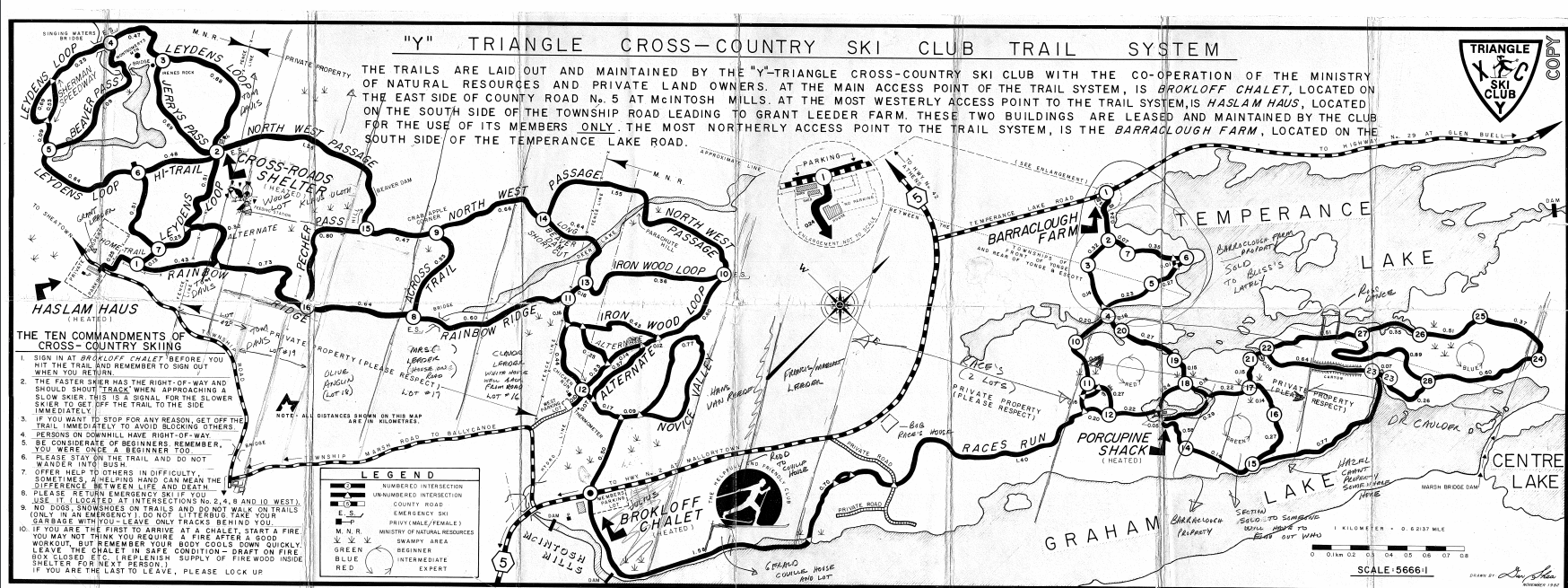
One of the original trail maps Circa early eighties
Club trails are mainly suited to classical skiing with the exception of Walsh Way (seen at the bottom right of he map) which can be used to skate ski. This trail is a 2 kms loop crossing the marsh behind the chalet site and continuing through a plantation of mature pine trees. Novice Valley is a classical ski loop off Walsh Way. These two trails originate from the parking lot and are ideal for novice skiers.
There is a fence across the entrance to Leeders Lane trail which has been erected by the landowner to prevent motorized vehicles crossing his land. Skiers may step around the fence to use this trail. The trail will be ski set rather than track set. This season we will not be able to ski to the East trails from Junction 21 on the West circuit. Leeder's Lane will have a loop near the old sugar shanty, so it will not be a dead end. Maps do not reflect this late change unfortunately but trails will be posted soon.
Ironwood Loop proceeds westerly through a tree lined valley with rocky ridges that form part of the Frontenac Axis.
The extreme western area of the map is Leyden's Loop and is suited to intermediate and expert skiers. This is a very picturesque trail.
Leydens Loop is reached by way of Rainbow Ridge with its lookout point above Leeders Creek - well worth a pause. This section of the trail is well sheltered in the trees, as are most of the trails, through undulating terrain calling for intermediate skiing skills.
Cross Roads Shelter is accessed via Rainbow Ridge and is located on Leydens Loop.
Parachute Hill, the largest hill on the club's trail system, is on Northwest Passage which is located at the northern extreme of the trails. Due to extensive damage by multiple all-terrain vehicles over the past several years skiers should use caution if skiing down Parachute Hill. Ski the Northwest Passage trail via Parachute Hill in a clockwise direction to avoid the downhill.
The same conditions exist on the trails off Leyden’s Loop. Skiers wishing to ski around the actual loop should exercise caution.
For Mountain Biking, Fat Biking, Hiking & Trail Running Maps
|

For Segment Loops, Leader Boards
and Routes |

Ideal for most trails and loops at McIntosh Mills.
|

Ideal for Triangle Cross Country Ski club and Snowshoe Maps
|

Downloadable & Offline Maps. Leave you cell service behind.
|